Scientists have begun using satellites that can produce high-resolution imagery to monitor whale strandings from space, according to a new study.
Back in 2015, Chile saw one of the largest mass mortality of baleen whales in recorded history, tallying at least 343 whales. But the remote location of the stranding meant that it went unreported for weeks, after which whales went missing and decomposition made it hard to determine how the whales died. Perhaps satellites could one day prove to be a simpler, more affordable way to study these strandings than present day networks and aerial surveys.
“It’s important that we harness human technological advancements to do a better job understanding and protecting the natural world,” Jennifer Jackson, molecular phylogeneticist at the British Antarctic Survey, told Earther.
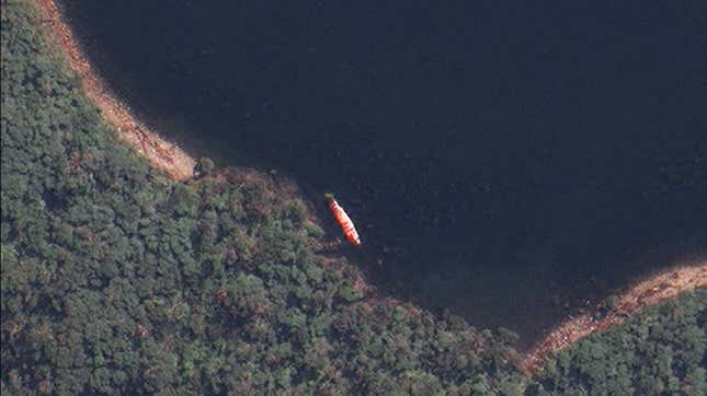
Scientists spotted the 2015 stranding in a survey flight over the incredibly remote, rugged location on the southern Chilean coast, consisting mostly of sei whales. They aren’t as large as blue whales or humpbacked whales, but sei whales are still huge, measuring around 50 feet or more in length and weighing around 20 tons. You can imagine that if a satellite can make out a truck on a road, then it could probably make out a sei whale.

The researchers, led by Preter Fretwell at the British Antarctic Survey, collected archival satellite imagery from before the aerial survey, which could get down to a half-meter resolution in black and white and 2-meter resolution in 8 color bands. After processing the images, they manually analyzed the images for whale shapes, sorted the shapes into classes based on how confident they were that it was really a whale, and analyzed the wavelengths of light that appeared in the images. They further ran an automated analysis to find these whale-like shapes.
These images demonstrated slight differences from the aerial surveys: in one case, whales found in aerial surveys were not located in satellite images. In another, the satellite images revealed far more whales than the aerial survey. The discrepancy was based in part the time elapsed between the different survey methods as the whales could have shifted in the water.
It turns out that the aerial images alone could have been undercounting the number of stranded whales, according to the paper published in PLOS One on Thursday. The researchers also wrote that red and near-infrared wavelengths might be able to determine the difference between whale and not whale in ambiguous cases because decomposing sei whales turn a lightish sandy color that can make them hard to spot.

Satellites offer several potential benefits for monitoring strandings, Jackson explained. They can provide data sooner after the stranding, giving better estimates before natural forces move whale corpses around. And they can even offer context clues as to what may have killed the whales.
“It’s very unusual that we have so many whales dying in one particular spot,” Carlos Olavarría, Executive Director of the Center for Advanced Studies of Arid Zones in Chile and one of the study’s authors, told Earther. “It tells us that there’s something happening in the whole environment. We need to be closer to the time when these animals die so we can know what’s happening in the whole surrounding environment.”
As for the 2015 strandings, Chilean researchers have realized smaller events occur annually in the area during the southern hemisphere summer, and the same time that a mass salmon die-off recently occurred in the area. Recent research has suggested that toxic algal blooms might be to blame.
The new study represents a first step in using satellites for tracking whale strandings, but there’s work yet to be done. Manually scanning satellite images is time consuming, and researchers hope to eventually employ machine learning techniques to pick whale corpses out of the images. Additionally, this method probably can’t save whales’ lives, particularly since the satellites can only take images when they’re directly over the area of interest and there’s no cloud cover. Jackson told Gizmodo this occurs every four weeks, approximately.
Still, the satellite images will hopefully help researchers get the 30,000 foot view (well, technically the 435-mile-view) of whale stranding problems not just in Chile but around the world.